Training on atmospheric dispersion in urban environments
6. Atmospheric dispersion modeling in urban areas
In urban areas, the buildings act as the walls of an urban canyon. The structure of the urban canyons interacts, especially in the case of tall buildings, with the atmospheric airflow producing complex wind patterns. This results in local concentration patterns that are different from what would result from a simple Gaussian model.
To correctly model atmospheric dispersion in urban conditions, it is necessary to explicitly account for the effect of buildings, capture the essential physics of the dispersion process, and provide reasonable estimates of downwind concentrations.
Different sophisticated mathematical models can be used to predict urban airflows. EC-EERS has developed such a model based on computational fluid dynamics (CFD). It accounts for topography, turbulence and obstacles in order to obtain more accurate estimates of the dispersed cloud extent and its effect. Which standard Gaussian or operational Lagrangian / Eulerian models cannot provide. However, calculations with these models require scientific expertise and demand significant computer resources.
Basic description of CUDM (Canadian Urban Dispersion Modeling System)
EC-EERS can simulate atmospheric releases anywhere over the globe at different resolutions but has currently no operational tools that take into consideration the complex wind flow around the buildings in an urban environment. To fill this gap, the CUDM system has been designed to predict wind flow, and the resulting dispersion of pollutants, within the urban environment, allowing airborne CBRN (Chemical, Biological, radiological and Nuclear) materials to be tracked at the scale of streets and buildings.
The CUDM system consists of three major components. The first component is a cascade of Numerical Weather Prediction (NWP) models that run at progressively higher resolution. This cascade is designed to provide high-resolution wind fields required by urban flow models, and includes parameterizations to simulate the effects of built-up areas (cities) on NWP winds. In its full configuration, the cascade produces wind fields at 250 m resolution (as compared to 10 km for the current operational Canadian regional NWP model). The cascade provides boundary conditions to the second component, a Computational Fluid Dynamics (CFD) model. This component explicitly resolves buildings at a resolution of 1 to 10 m and calculates the wind and turbulence fields needed by the third component, an urban-scale dispersion model that calculates the transport and dispersion of pollutants along streets and around buildings. The figure 6.1 represents a diagram of the CUDM system.
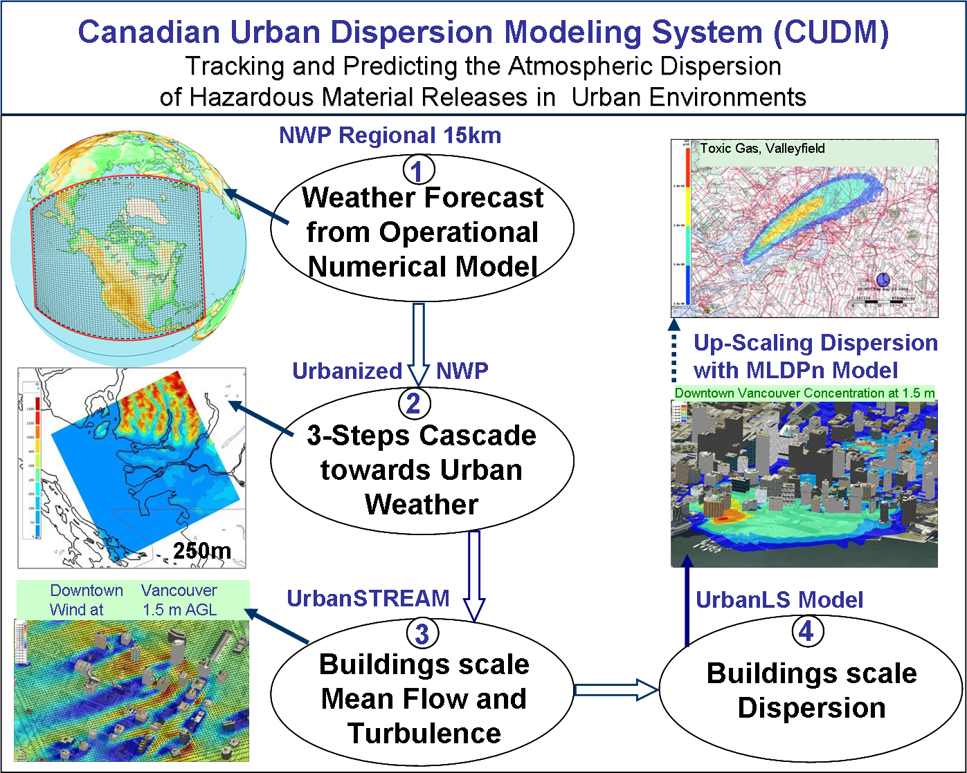
Figure 6.1: The three main components of the CUDM system. The NWP cascade uses successively higher resolution versions of the GEM model. These provide boundary conditions for the CFD model urbanSTREAM, which calculates the complex wind flow around buildings. The dispersion model urbanLS computes trajectories of particles released into the wind calculated by the CFD model.
N.B.: It should be noted that the details of the source term (type, quantity, location and method of release, etc.) are rarely known at the initial time when responding to emergencies. Also, CBRN products may interact with other chemical components and may be modified by environmental conditions. In its current form, the CUDM system is used to estimate the evolution of the plume of toxic products in urban areas, using a passive tracer approach. The pollutant concentrations and their effects on human health are not presented.